- Page 1 and 2:
Report to:Pretium Resources Inc.Fea
- Page 3 and 4:
TABLE OF CONTENTS1.0 SUMMARY ......
- Page 5 and 6:
12.2 DATA VERIFICATION BY SNOWDEN .
- Page 7 and 8:
16.7 MOBILE EQUIPMENT REQUIREMENTS
- Page 9 and 10:
20.1 SUSTAINABILITY AND ENVIRONMENT
- Page 11 and 12:
26.4.2 HYDROGEOLOGICAL RECOMMENDATI
- Page 13 and 14:
Table 13.23 Occurrences of Gold in
- Page 15 and 16:
LIST OF FIGURESFigure 1.1 Simplifie
- Page 17 and 18:
Figure 16.11 Extent of Mine Develop
- Page 19 and 20:
hertz .............................
- Page 21 and 22:
atomic emission spectroscopy ......
- Page 23 and 24:
Mineable Shape Optimizer ..........
- Page 25 and 26:
VOK Domain 2 ......................
- Page 27 and 28:
1.2 PROPERTY DESCRIPTION AND LOCATI
- Page 29 and 30:
1.4 MINERAL RESOURCE ESTIMATESSnowd
- Page 31 and 32:
Table 1.2West Zone Mineral Resource
- Page 33 and 34:
Figure 1.1Simplified Process Flowsh
- Page 35 and 36:
1.7 MINING METHODSThe underground m
- Page 37 and 38:
Figure 1.2Overall Site LayoutE 4300
- Page 39 and 40:
Figure 1.4Knipple Transfer Station
- Page 41 and 42:
outflow. This approachdischarge thr
- Page 43 and 44:
summary of the overall operating co
- Page 45 and 46:
The Project schedule identifies the
- Page 47 and 48:
2.1 QUALIFIED PERSONSThe qualified
- Page 49 and 50:
Report Section Company QP23.0 Adjac
- Page 51 and 52:
4.0 PROPERTY DESCRIPTION AND LOCATI
- Page 53 and 54:
4.3 STATUS OF MINING TITLESThe Prop
- Page 55 and 56:
Figure 4.3Pretivm Mineral ClaimsSou
- Page 57 and 58:
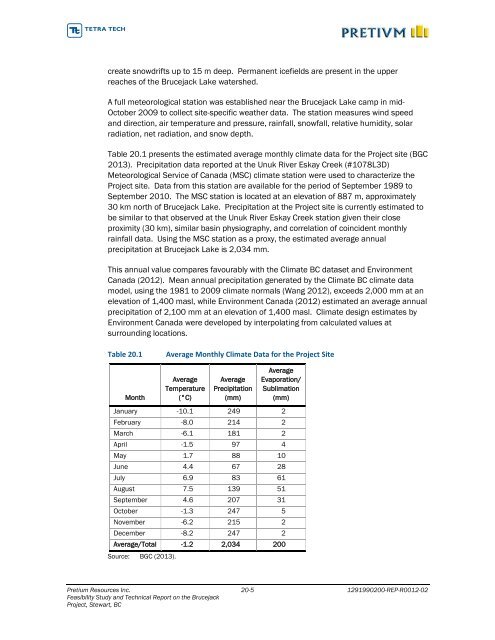
5.0 ACCESSIBILITY, CLIMATE, LOCALRE
- Page 59 and 60:
5.2 CLIMATE AND PHYSIOGRAPHYThe cli
- Page 61 and 62:
6.0 HISTORYInformation in this sect
- Page 63 and 64:
Figure 6.1West Zone Underground Vei
- Page 65 and 66:
6.1 WORK COMPLETED BY SILVER STANDA
- Page 67 and 68:
7.0 GEOLOGICAL SETTING ANDMINERALIZ
- Page 69 and 70:
Figure 7.1Tectonic Setting of the B
- Page 71 and 72:
7.2 LOCAL GEOLOGY - SULPHURETS MINI
- Page 73 and 74:
Altered Stuhini Group rocks and Mit
- Page 75 and 76:
Figure 7.4Sulphurets Mining Camp Ge
- Page 77 and 78:
y the Brucejack Fault as well as by
- Page 79 and 80:
Previously, some of the rocks strad
- Page 81 and 82:
Figure 7.6Brucejack Property Geolog
- Page 83 and 84:
Figure 7.6 (con’t)Brucejack Prope
- Page 85 and 86:
more distal (i.e. down temperature)
- Page 87 and 88:
more heavily altered than those abo
- Page 89 and 90:
Figure 7.8Brucejack Property Minera
- Page 91 and 92:
Figure 7.10South-north Cross-sectio
- Page 93 and 94:
WEST ZONEThe West Zone gold-silver
- Page 95 and 96:
Figure 7.12VOK to West Zone Geologi
- Page 97 and 98:
Figure 7.14West Zone Drillholes and
- Page 99 and 100:
steep, is generally associated with
- Page 101 and 102:
Figure 7.15Trace Element Analysis b
- Page 103 and 104:
for which an age of c.110 Ma has be
- Page 105 and 106:
Figure 8.1Brucejack Deposit Mineral
- Page 107 and 108:
Figure 9.13D Geophysical Model Sche
- Page 109 and 110:
10.0 DRILLINGInformation in this se
- Page 111 and 112:
Figure 10.1Core in Wooden Core Boxe
- Page 113 and 114:
Figure 10.3Brucejack Property Diamo
- Page 115 and 116:
The cut PQ samples weighed approxim
- Page 117 and 118:
submitted to ALS. In addition, a re
- Page 119 and 120:
Primary sample gold concentrations
- Page 121 and 122:
12.0 DATA VERIFICATIONIndependent s
- Page 123 and 124:
12.2 DATA VERIFICATION BY SNOWDENSn
- Page 125 and 126:
Figure 12.4Sample Verification Resu
- Page 127 and 128:
Year Program ID Laboratory ** Gravi
- Page 129 and 130:
13.3.2 2012 TO 2013 TEST SAMPLESIns
- Page 131 and 132:
Table 13.7 Conceptual Master Compos
- Page 133 and 134:
ALSInspectorateFire Assay (g/t) Met
- Page 135 and 136:
13.3.6 ORE HARDNESS TEST WORKTable
- Page 137 and 138:
Table 13.14 Sample Specific Gravity
- Page 139 and 140:
In general, there was a reduction i
- Page 141 and 142:
Figure 13.5 Effect of Primary Grind
- Page 143 and 144:
In 2012 and 2013, most of the flota
- Page 145 and 146:
Further cleaner tests were conducte
- Page 147 and 148:
Figure 13.14 Effect of Cleaner Flot
- Page 149 and 150:
SampleIDWZ-2CompositeCompositeBJ-AC
- Page 151 and 152:
The 2012 and 2013 tests routinely i
- Page 153 and 154:
Figure 13.17Cumulative Stage GRG ve
- Page 158 and 159:
Figure 13.21 Silver Cyanide Extract
- Page 160 and 161:
Table 13.24 Head Sample Cyanidation
- Page 162 and 163:
Based on the findings of the prelim
- Page 164 and 165:
Primary Grind/Regrind SizesConcentr
- Page 166 and 167:
Further cyanide leach tests were ca
- Page 168 and 169:
including samples with low head gra
- Page 170 and 171:
Grade (g/t) Recovery/Extraction (%)
- Page 172 and 173:
Figure 13.28 Variability Test Resul
- Page 174 and 175:
Table 13.31Locked Cycle Tests Resul
- Page 176 and 177:
Table 13.33Conventional Thickening
- Page 178 and 179:
13.3.11 CONCLUSIONSA review of prel
- Page 180 and 181:
Table 13.37Head Grade(g/t)Metallurg
- Page 182 and 183:
• geological interpretation and m
- Page 184 and 185:
to form a series of seemingly strat
- Page 186 and 187:
14.6 COMPOSITING OF ASSAY INTERVALS
- Page 188 and 189:
In the high-grade domains (includin
- Page 190 and 191:
Table 14.3Parameters to Describe Go
- Page 192 and 193:
14.8.3 HIGH-GRADE DOMAINS - PROBABI
- Page 194 and 195:
analysis. Any target blocks that re
- Page 196 and 197:
For VOK and West Zone the interpola
- Page 198 and 199:
Table 14.9Comparison of the Mean Co
- Page 200 and 201:
the economic viability of the depos
- Page 202 and 203:
14.15 RESOURCE REPORTINGThe mineral
- Page 204 and 205:
15.0 MINERAL RESERVE ESTIMATES15.1
- Page 206 and 207:
Table 15.1Net Smelter Return Parame
- Page 208 and 209:
15.4 MINING SHAPESAMC used the Mine
- Page 210 and 211:
Strike length varies considerably w
- Page 212 and 213:
15.7 MINERAL RESERVESMineral reserv
- Page 214 and 215:
Figure 15.4Reserve Shapes and Minin
- Page 216 and 217:
16.2 MINE DESIGN16.2.1 ACCESS AND R
- Page 218 and 219:
Figure 16.2Brucejack Twin Declines
- Page 220 and 221:
Figure 16.4Typical Level Plan - 1,2
- Page 222 and 223:
Table 16.1Development Design Parame
- Page 224 and 225:
Figure 16.7Mineable Stope Shapes -
- Page 226 and 227:
Once the stope footprint is slashed
- Page 228 and 229:
16.3.3 STOPE SEQUENCEThe mining seq
- Page 230 and 231:
Stopes that will not be re-exposed
- Page 232 and 233:
Table 16.5LOM Backfilling - Waste R
- Page 234 and 235:
Figure 16.11Extent of Mine Developm
- Page 236 and 237:
• development of the 1,210 and 1,
- Page 238 and 239:
Figure 16.13Life of Mine Production
- Page 240 and 241:
Table 16.7LOM Tonnes and GradesYear
- Page 242 and 243:
Table 16.8Rock Mass PropertiesUnitU
- Page 244 and 245:
AMC estimated ore recovery in the w
- Page 246 and 247:
FULL-WIDTH UNDERCUTSThe Project min
- Page 248 and 249:
Table 16.10Mine Infrastructure Exca
- Page 251 and 252:
with lesser components supplied by
- Page 253 and 254:
un was completed representing glaci
- Page 255 and 256:
Table 16.12Underground Development
- Page 257 and 258:
TRANSMIXERSShotcrete will be delive
- Page 259 and 260:
The VOK Zone and West Zone mining a
- Page 261 and 262:
Figure 16.17 shows a ventilation co
- Page 263 and 264:
• regular inspection of the conve
- Page 265 and 266:
On low-head applications, a submers
- Page 267 and 268:
Figure 16.18Dewatering PlanPretium
- Page 269 and 270:
Figure 16.20CrusherThe 42 in wide b
- Page 271 and 272:
16.9.3 POWER REQUIREMENTS AND ELECT
- Page 273 and 274:
Electrical power will be supplied t
- Page 275 and 276:
To supply service water to the high
- Page 277 and 278:
16.9.7 WORKSHOP AND STORESThe maint
- Page 279 and 280:
Radio communications will be establ
- Page 281 and 282:
16.9.11 PORTAL STRUCTUREA portal st
- Page 283 and 284:
propane consumption. Table 16.18 sh
- Page 285 and 286:
16.10 PASTE FILL DISTRIBUTIONP&C co
- Page 287 and 288:
Figure 16.33Paste Fill Distribution
- Page 289 and 290:
Figure 16.35Pre-production Paste Fi
- Page 291 and 292:
RoleHeadCountMaintenance (72)Mainte
- Page 293 and 294:
17.0 RECOVERY METHODS17.1 MINERAL P
- Page 295 and 296:
The process plant will consist of t
- Page 297 and 298:
17.1.4 PLANT DESIGNMAJOR DESIGN CRI
- Page 299 and 300:
• a belt conveyor, 914 mm wide by
- Page 301 and 302:
CONCENTRATE REGRINDINGThe flotation
- Page 303 and 304:
The dried tabling concentrate will
- Page 305 and 306:
solution strength. The solution wil
- Page 307 and 308:
PROCESS CONTROL AND INSTRUMENTATION
- Page 309 and 310:
• vendors’ instrumentation pack
- Page 311 and 312:
18.0 PROJECT INFRASTRUCTURE18.1 OVE
- Page 313 and 314:
Figure 18.1Brucejack Overall Site L
- Page 315 and 316:
18.2 GEOTECHNICAL18.2.1 OVERVIEWThe
- Page 317 and 318: 18.3 ACCESS18.3.1 ACCESS ROADSThe B
- Page 319 and 320: Figure 18.3Knipple Glacier Access R
- Page 321 and 322: available in the winter and also pr
- Page 323 and 324: 18.5 GRADING AND DRAINAGEThe site w
- Page 325 and 326: AVALANCHE FREQUENCYAvalanche freque
- Page 327 and 328: • portal fuel storage• conveyor
- Page 329 and 330: Operations CampSize 2 avalanches fr
- Page 331 and 332: Figure 18.5Access Road Avalanche Ha
- Page 333 and 334: and dated June 2013. As requested b
- Page 335 and 336: Figure 18.7Photo of Typical Slopes
- Page 337 and 338: • the design of special towers to
- Page 339 and 340: modular construction where possible
- Page 341 and 342: collect waste water during maintena
- Page 343 and 344: water treatment plant to increase t
- Page 345 and 346: Air/vacuum valves will be installed
- Page 347 and 348: Figure 18.10Foot Print of 3% Deposi
- Page 349 and 350: A pre-manufactured trailer will be
- Page 351 and 352: • fuel storage• vendors’ inst
- Page 353 and 354: 18.17 OFF-SITE INFRASTRUCTURE18.17.
- Page 355 and 356: 18.17.3 BOWSER AIRSTRIPRegular char
- Page 357 and 358: INSTRUMENT APPROACH PROCEDURESAn IA
- Page 359 and 360: AERODROME PERSONNEL AND MAINTENANCE
- Page 361 and 362: TRANSPORT MODE OPTIONSTruckThere ar
- Page 363 and 364: SBT has the ability to mobilize cra
- Page 365 and 366: Pretivm is committed to a process t
- Page 367: engage with the Nisga’a Lisims Go
- Page 371 and 372: The fisheries resources and fish ha
- Page 373 and 374: was conducted on the NPR values of
- Page 375 and 376: all modelling exercises, the accura
- Page 377 and 378: 16 corridor is recovering from the
- Page 379 and 380: • reporting and feedback mechanis
- Page 381 and 382: Approximately 47% of the tailings w
- Page 383 and 384: 20.1.8 WASTE MANAGEMENTMine WastesP
- Page 385 and 386: from the site. Fixed equipment, suc
- Page 387 and 388: • Forest Act (BC)• Forest and R
- Page 389 and 390: Table 20.5List of Federal Approvals
- Page 391 and 392: 21.1.2 ESTIMATE BASE DATE AND VALID
- Page 393 and 394: …costs not directly attributable
- Page 395 and 396: • small tools• consumables• c
- Page 397 and 398: The total cost for Major Area 33 -
- Page 399 and 400: The unit cost estimates are based o
- Page 401 and 402: MINE OPERATING COSTSThe total under
- Page 403 and 404: Table 21.7Summary of Process Operat
- Page 405 and 406: Table 21.8Summary of Backfilling Op
- Page 407 and 408: DescriptionLabourForceTotal Cost($/
- Page 409 and 410: 22.0 ECONOMIC ANALYSIS22.1 INTRODUC
- Page 411 and 412: Figure 22.1Pre-tax Cash FlowCumulat
- Page 413 and 414: transport the concentrate to a buil
- Page 415 and 416: Figure 22.4Pre-tax Payback Period S
- Page 417 and 418: Canadian development expense and 60
- Page 419 and 420:
23.0 ADJACENT PROPERTIESSnowden not
- Page 421 and 422:
23.2 HIGH PROPERTYThe Teuton Resour
- Page 423 and 424:
managers, and the mining manager, a
- Page 425 and 426:
MANAGEMENT PROCEDURESThe EPCM contr
- Page 427 and 428:
Figure 24.2Level 1 Execution Schedu
- Page 429 and 430:
Capital equipment purchases will be
- Page 431 and 432:
Construction work will be split int
- Page 433 and 434:
provided with dedicated emergency p
- Page 435 and 436:
econciliation to the freight consol
- Page 437 and 438:
PROJECT TEAM RESPONSIBILITIESIt is
- Page 439 and 440:
WBS Area PretivmEPCMTeamUnderground
- Page 441 and 442:
24.1.15 RISK MANAGEMENTA Risk Asses
- Page 443 and 444:
There may be opportunities to optim
- Page 445 and 446:
The conceptual layout is preliminar
- Page 447 and 448:
25.4.8 TAILINGS DELIVERY SYSTEMThe
- Page 449 and 450:
26.0 RECOMENDATIONS26.1 GEOLOGYThe
- Page 451 and 452:
• Further test work to identify t
- Page 453 and 454:
The estimated cost for the above-me
- Page 455 and 456:
• Careful planning as well as det
- Page 457 and 458:
26.5.6 BRUCEJACK OUTLET CONTROL STR
- Page 459 and 460:
• Further groundwater quality and
- Page 461 and 462:
27.0 REFERENCES27.1 AVALANCHE HAZAR
- Page 463 and 464:
Price, W. (2005). Mend Report 9.1c:
- Page 465 and 466:
Britton, J. M. and Alldrick, D. J.,
- Page 467 and 468:
Olssen. L., Jones, I.. 2012b. Preti
- Page 469 and 470:
28.0 CERTIFICATES OF QUALIFIED PERS
- Page 471 and 472:
28.2 IVOR W.O. JONES, M.SC., CP, FA
- Page 473 and 474:
28.3 JOHN HUANG, PH.D., P.ENG.I, Ji
- Page 475 and 476:
28.5 HAMISH WEATHERLY, M.SC., P.GEO
- Page 477 and 478:
28.7 SABRY ABDEL HAFEZ, PH.D., P.EN
- Page 479 and 480:
28.9 CATHERINE SCHMID, M.SC., P.ENG
- Page 481 and 482:
28.11 BRENT MCAFEE, P.ENG.I, Brent
- Page 483 and 484:
28.13 MICHAEL CHIN, P.ENG.I, Michae
- Page 485 and 486:
28.15 MICHAEL PAUL WISE, P.ENG., MB
- Page 487 and 488:
28.17 CLAYTON RICHARDS, P.ENG.I, Cl
- Page 489 and 490:
28.19 ALI FARAH, P.ENG.I, Ali Farah
- Page 491 and 492:
28.21 S. (KUMAR) SRISKANDAKUMAR, M.