- Page 4:
PresentaciónAfines del 2005 el CED
- Page 9 and 10:
extensas, por ejemplo, los que se l
- Page 11:
Clima intertropical: cálido, las t
- Page 14 and 15:
Clasificación del ser humanoReino:
- Page 16:
F loraAspectos GeneralesCuando habl
- Page 21 and 22:
en algunos productos representativo
- Page 23:
Tabla 4. Plantas alimenticias de or
- Page 29:
Las proteínas forman parte de todo
- Page 34 and 35:
Tabla 10. Características y rendim
- Page 37 and 38:
Tabla 13. Variedades y ecotipos de
- Page 39 and 40:
Tabla 14. Razas de tarwi en Bolivia
- Page 42 and 43:
Mapa 4Áreas forestales en BoliviaM
- Page 44 and 45:
Tabla 17. Tierras de Producción Fo
- Page 46:
cies, sin embargo, actualmente se p
- Page 49 and 50:
Tabla 19. Número de derechos fores
- Page 51 and 52:
Estas modalidades de derecho se ori
- Page 53 and 54:
Tabla 25. Evolución de áreas cert
- Page 58 and 59:
Considerando las especies principal
- Page 60 and 61:
derecho de uso del recurso forestal
- Page 62 and 63:
• Los municipios a través de la
- Page 64 and 65:
partamento de La Paz. El área cast
- Page 66 and 67:
• Formas de producción, comercia
- Page 68 and 69:
La producción anual de goma en bol
- Page 70 and 71:
PIB nacional, y genera 22 mil puest
- Page 72 and 73:
F aunaAspectos generalesLa fauna de
- Page 74 and 75:
Mapa 7Áreas importantes para lacon
- Page 76 and 77:
los ophidia, conocidos con el nombr
- Page 78 and 79:
Ilustración 10.Diversidad de espec
- Page 80 and 81:
Ilustración 12. Estructura de la e
- Page 82 and 83:
Tabla 37. Especies de vertebrados p
- Page 84 and 85:
Tabla 38. Interacción del aborigen
- Page 86 and 87:
Tabla 40. Número de cabezas de gan
- Page 88 and 89: Tabla 42. Mataderos registrados y s
- Page 90 and 91: Tabla 44. Número de cabezas de gan
- Page 92 and 93: Ilustración 17. Evolución compara
- Page 94 and 95: El principal resultado del sistema
- Page 96 and 97: PotencialLa demanda de carne de lla
- Page 98 and 99: PescaAspectos generalesEn Bolivia s
- Page 100 and 101: de la cuenca del Altiplano. En 1955
- Page 102 and 103: EmpleoEn 1999 el sector pesquero di
- Page 104: pecuarios tiene una participación
- Page 107 and 108: Tabla 59. Distribución del agua en
- Page 109 and 110: Tabla 60. Principales vertientes hi
- Page 111 and 112: Provincias hidrogeológicasLa impor
- Page 113 and 114: 5. Además existen humedales constr
- Page 115 and 116: Ilustración 18. Comportamiento del
- Page 117 and 118: Ilustración 19. Evolución de la e
- Page 119 and 120: Luego tenemos a los usuarios, que e
- Page 121 and 122: ) Productores comunales del Oriente
- Page 123 and 124: Tabla 68. Consumo de agua potable p
- Page 125 and 126: Descripción y análisis de los act
- Page 127 and 128: derivados, Atrazina, Etiocina, Linu
- Page 129 and 130: mediana cumplen con las regulacione
- Page 131 and 132: componentes sulfurosos; y de las ag
- Page 133 and 134: Tabla 72. Caracterización de las a
- Page 135 and 136: El 30 de enero del 2000, se produjo
- Page 137: Los redactores del informe también
- Page 141 and 142: volúmenes de pasivos ambientales m
- Page 144 and 145: R ecursosnaturales renovablesUna re
- Page 146 and 147: R eseñade la historia del Medioamb
- Page 148 and 149: La historiografía del medioambient
- Page 150 and 151: energéticos debido a la competenci
- Page 152 and 153: B revereseña histórica de losRecu
- Page 154 and 155: Aún había plata, pero en profundi
- Page 156 and 157: Ilustración 1. Producción bolivia
- Page 158 and 159: Ilustración 2. Precios de la tonel
- Page 160 and 161: enfiló hacia la creación de reser
- Page 162 and 163: Continuando con las “eras” desp
- Page 164 and 165: L aRevolución VerdeExisten dos ide
- Page 166 and 167: y Catholic Relief Services con la a
- Page 168 and 169: descentralizado e interrelacionado
- Page 170 and 171: B iotecnologíaen Bolivia¿Qué es
- Page 172 and 173: independiente de estos. El resultad
- Page 174 and 175: o Milo de Argentina y Brasil; aceit
- Page 176 and 177: hace más resistente a medida que s
- Page 178 and 179: erosión y contaminación por agroq
- Page 180 and 181: cias carcinogénicas u otras severa
- Page 182 and 183: alimentaria enviada por USAID a Lat
- Page 184 and 185: B iocomercioHistoria del interés e
- Page 186 and 187: ióticos, a través de todo un sist
- Page 188 and 189:
control hasta que lo considere conv
- Page 190 and 191:
más de 300 especies de plantas que
- Page 192 and 193:
Cuando el comercio de animales silv
- Page 194 and 195:
Tabla 6. Comercio en Merbau, Mara y
- Page 196 and 197:
autorización cuando la autoridad n
- Page 198 and 199:
periodos de cacería que se contrap
- Page 200 and 201:
Dada la interrelación entre las es
- Page 202:
Instrumentos legales de protección
- Page 205 and 206:
mente, tanto la legislación como l
- Page 207 and 208:
Tabla 9. Regiones del país en buen
- Page 209 and 210:
Existen cinco diferentes categoría
- Page 211 and 212:
Abaroa (impactos de la minería y e
- Page 213 and 214:
Respecto al contenido o calidad de
- Page 215 and 216:
sociedad civil del norte amazónico
- Page 217 and 218:
presos a varios de sus miembros. En
- Page 219 and 220:
Según el convenio firmado entre co
- Page 221 and 222:
ella, y por otra, realizando una ca
- Page 223 and 224:
del Beni (CPIB) y la Central indíg
- Page 225 and 226:
del norte amazónico (Pando y Beni)
- Page 227 and 228:
la prefectura de Potosí rescinde l
- Page 229 and 230:
para el diálogo 22 según la estra
- Page 231 and 232:
de los riesgos que podría implicar
- Page 233 and 234:
1. El desarrollo de la confianza mu
- Page 235 and 236:
La Autoridad Ambiental Competente q
- Page 237 and 238:
centración, fundición y comercial
- Page 239 and 240:
Política de EstadoLos problemas po
- Page 241 and 242:
El Proyecto de Constitución de laA
- Page 243 and 244:
cesariamente que ver con la industr
- Page 245 and 246:
Las Modificaciones al Proyecto deCo
- Page 247 and 248:
de extranjeros, se pierde y es reem
- Page 249 and 250:
Participación y control socialEl a
- Page 251 and 252:
nota de la Tabla 15, para comprende
- Page 253 and 254:
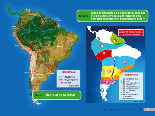
y administración de aeropuertos in
- Page 255 and 256:
La caracterización de los recursos
- Page 257 and 258:
la burocracia de los tres poderes d
- Page 259 and 260:
Contenido de la Primera ParteCONCEP
- Page 261 and 262:
MAPAS- Mapa 1. Las temperaturas en
- Page 263 and 264:
Contenido de la Segunda ParteRECURS
- Page 265 and 266:
Bibliografía (Partes 1 y 2)- Abell
- Page 267 and 268:
- Kaczewer, Jorge. (2006).Toxicolog
- Page 269 and 270:
- Secretaría Nacional de Agricultu