MaxSea Operator Manual version 12.6 - Furuno USA
MaxSea Operator Manual version 12.6 - Furuno USA
MaxSea Operator Manual version 12.6 - Furuno USA

You also want an ePaper? Increase the reach of your titles
YUMPU automatically turns print PDFs into web optimized ePapers that Google loves.
Electronic Charts<br />
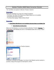
The "Change Config" window allows you to destroy or create your own config by choosing options under a table<br />
as it is described below:<br />
Select an option NAME : To display on chart :<br />
Text / Names Cartographic line, Text, Text...<br />
Traffic info Ferry route, Signal station, traffic, Traffic separation line, Traffic separation<br />
scheme boundary, Traffic separation scheme crossing, Traffic separation<br />
scheme lane part, Traffic separation scheme roundabout, Traffic separation<br />
zone, Two-way route part, Cartographic area, Cartographic area...<br />
Small Craft facilities Small craft facility<br />
Low Nav info Anchor berth, Anchorage area, Cable area, Cable, overhead, Cable,<br />
submarine, Caution area, Dumping ground, Fairway, Fog signal, Ice area,<br />
Local magnetic anomaly, Magnetic variation, Offshore platform, Military<br />
practice area, Offshore production area, Pilot boarding place, Pipeline area,<br />
Radar transponder beacon, Recommended track, Restricted area, Submarine<br />
transit lane, Top mark, Top mark...<br />
Medium Nav info Berth, Contiguous zone, Distance mark, Exclusive economic zone, Ferry route,<br />
Marine farm/culture, Pipeline, submarine/on land, Tideway, Cartographic line,<br />
Cartographic symbol, Compass, Text, Text...<br />
Objects Low info Airport area, Building, single, Built-up area, Cargo transhipment area, Dam,<br />
Dyke, Fishing ground, Incineration area, Lake shore, Navigation line, Radar<br />
line, Radar range, Radar reflector, Radar station, River, River bank, Sea-plane<br />
landing area, Signal station, warning, Silo/tank, Sloping ground, Waterfall,<br />
Waterfall...<br />
Objects Medium info Canal bank, Causeway, Checkpoint, Coast guard station, Coastline,<br />
Contiguous zone, Continental shelf area, Control point, Conveyor, Crane,<br />
Current - non-gravitational, Custom zone, Day mark, Deep water route<br />
centerline, Dry dock, Dyke, Fairway, Fence/wall, Fishery zone, Fishing facility,<br />
Fog signal, Fortified structure, Free port area, Gate, Gridiron, harbor area<br />
(administrative), harbor facility, Inshore traffic zone, Lake, Marine farm/culture,<br />
Military practice area, Mooring/Warping facility, Navigation line, Pile, Pilot<br />
boarding place, Production/storage area, Radio station, Railway, Rapids,<br />
Recommended track, Rescue station, Retro-reflector, Road, Runway, Sand<br />
waves, Sea area/named water area, Sea-plane landing area, Seabed area,<br />
Signal station, traffic, Slope top line, Sloping ground, Spring, Square, Straight<br />
territorial sea baseline, Swept area, Territorial sea area, Tidal stream -<br />
harmonic prediction, Tidal stream - non-harmonic prediction, Tidal stream<br />
panel data, Tidal stream - time series, Tide - harmonic prediction, Tide - nonharmonic<br />
prediction, Tide - time series, Traffic separation scheme roundabout,<br />
Traffic separation zone, Tunnel, Unsurveyed area, Vegetation, Water<br />
turbulence, Weed/Kelp, Tidal stream - flood/ebb, Tidal stream - flood/ebb...<br />
Lights and buoys Light : Beacon, cardinal, Beacon, isolated danger, Beacon, lateral, Beacon,<br />
safe water, Beacon, special purpose/general, Buoy, cardinal, Buoy, installation,<br />
Buoy, isolated danger, Buoy, lateral, Buoy, safe water, Buoy, special purpose,<br />
Land area, Land elevation, Land region, Landmark, Light, Light float, Light<br />
vessel, Light vessel...<br />
Soundings Sounding<br />
Lights real range Displays dotted black lines showing the real range of lights.<br />
Simplified Symbols Displays object using S52 normalized / traditional presentation. Valid for buoys,<br />
lights…<br />
Int-1 (C-Map style) Use S52 normalized / C-Map style for chart display.<br />
Low detail scales Changes the <strong>MaxSea</strong>’s zoom where new charts appear.<br />
191