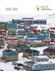
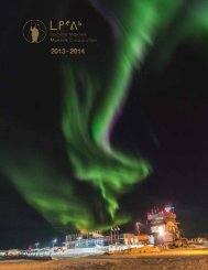
2013-2014 Makivik Annual Report
The 2014 Makivik Annual Report
The 2014 Makivik Annual Report

You also want an ePaper? Increase the reach of your titles
YUMPU automatically turns print PDFs into web optimized ePapers that Google loves.
ᐃᓄᑦᑕᖃᕋᓂ ᖃᖓᑕᓲᖑᑦᓱᓂ ᐊᑦᔨᓕᐅᕈᑎᑕᓕᒻᒧᑦ ᐱᖓᓱᓂᒃ ᓴᓂᕋᓕᓕᐅᕈᑎᒧᑦ ᐊᑦᔨᓕᐊᕕᓂᖅ (ᐅᒥᐊᒃᑯᕕᒃ, ᑰᒃᔪᐊᒥ).<br />
High resolution orthomosaic and 3 dimensional point cloud taken from the UAV helicopter (Marine Infrastructure, Kuujjuaq).<br />
Photo orthomosaïque haute résolution et en nuage de points tridimensionnels prise à l’aide d’un hélicoptère drone (Infrastructure maritime de Kuujjuaq).<br />
ᐱᖓᓱᐃᓂᒃ ᓴᓂᕋᓕᓐᓂᒃ ᐊᑦᔨᖑᐊᓂᒃ ᐊᑐᕐᑕᐅᒍᓐᓇᓯᐊᓚᕐᑐᓂᒃ ᓄᓇᒥᒃ ᐊᑐᕐᑕᖃᕐᓂᒥᒃ ᐊᑐᐃᓐᓇᕈᕐᑎᑐᓄᑦ, ᐊᓯᑦᔨᕙᓪᓕᐊᓂᕐᓂᓗ<br />
ᐃᑉᐱᒍᓱᒍᑎᐅᓗᑎᒃ, ᓄᐊᑦᑐᓂᓪᓗ ᐊᖏᓕᕙᓪᓕᐊᓂᖏᓐᓂᒃ ᐃᑉᐱᒍᓱᒍᑎᐅᓗᑎᒃ, ᐊᓯᖏᑎᒍᓪᓗ ᐊᑐᕐᑕᐅᖃᑦᑕᒥᓗᑎᒃ.<br />
ᓄᓇᕕᒻᒥ ᓄᓇᖕᖑᐊᓕᕆᓂᕐᓄᑦ ᐱᑦᔪᔨᕕᒃ ᑲᔪᓯᑦᓱᓂ ᐱᓇᓱᖃᑎᖃᖏᓐᓇᒥᔪᖅ Roche Ltd Consulting Group-ᑯᓐᓂᒃ ᐱᓇᓱᑦᑕᐅᔪᓂᒃ<br />
ᑲᑐᑦᔮᖃᖃᑎᒋᑦᓱᒋᑦ ᐊᒥᓱᐃᓄᑦ ᐱᑦᔪᔭᐅᔪᒪᐅᑎᓄᑦ ᐃᓕᖓᑦᓱᑎᒃ. ᐃᓚᐅᑎᓪᓗᒋᑦ ᓄᓇᐅᑉ ᐊᕙᑎᖓᓄᑦ ᖃᐅᔨᒪᔨᖃᕐᓂᓂᒃ ᐱᑦᔪᔨᔨᒃᑯᑦ<br />
ᑎᓕᔨᓯᒪᒍᑎᖏᑦ ᓇᐅᓕᒫᓂᒃ ᐱᓇᓱᒍᑦᔨᔨᒃᑯᓂᒃ, ᐱᑦᔪᔭᐅᒍᒪᐅᑎᖏᓪᓗ ᓄᓇᕗᑦ ᑲᕙᒪᒃᑯᖏᑕ ᐱᑕᖃᕐᑎᓯᖁᔨᑦᓱᑎᒃ ᐱᓇᓱᒍᑎᑦᓴᓂᒃ<br />
ᖃᐅᔨᓴᕐᓂᒥᒃ, ᖃᓄᐃᓕᒋᐊᕐᑎᖃᕈᒪᓂᒃᑯᓗ ᖃᐅᔨᓴᕐᑎᒋᓗᒋᓪᓗ, ᑖᒃᑯᐊ ᐊᒥᓱᐃᖑᑦᓱᑎᒃ ᐱᓇᓱᑦᑕᐅᒋᐊᓕᓐᓂᒃ ᑎᓕᔭᐅᒪᒍᑎᖃᕐᑐᑦ<br />
ᐱᑕᖃᕐᑎᓯᔨᐅᓛᕆᕗᑦ ᐃᓂᓪᓚᖓᐅᓯᑦᓴᓂᒃ ᐱᑦᔪᔨᒍᑎᓂᒃ ᐱᑦᔪᔨᓗᑎᒃ ᓄᓇᕗᑦ ᑲᕙᒪᖓᓂᒃ ᑐᖕᖓᕕᖃᕐᓗᑎᒃ ᑎᓕᔭᐅᒍᑎᑖᕆᓚᐅᔪᔭᒥᓐᓂᒃ<br />
<strong>2014</strong> ᐃᓱᓕᒋᐊᕕᓐᓂᓴᐅᓕᕐᑎᓗᒍ.<br />
community members. The final communities left to be interviewed,<br />
which include Akulivik, Puvirnituq, Inukjuak and Umiujaq and will<br />
be interviewed in February 2015. At the end of February 2015, all<br />
Nunavik communities will have been interviewed, however, some<br />
communities such as Inukjuak and Puvirnituq may require a second<br />
trip to increase the number of participants for the study.<br />
Land use planning work with the NMPRC and partner firms<br />
continue and a focus has been placed on potential protected areas<br />
in the offshore region. This work will be in close collaboration with<br />
the Kativik Regional Government who conducted similar workshops<br />
to identify potential protected areas for the onshore region.<br />
Through funding from Natural Resources Canada GeoConnections,<br />
Nunavik Geomatics along with ING Robotics and ASG Mapping<br />
spent a week in Kuujjuaq in September <strong>2014</strong> to operate and test an<br />
Unmanned Aerial Vehicle (UAV) capable of collecting high resolution<br />
imagery that has a variety of uses in the Nunavik region. Throughout<br />
the week, the field team collected imagery for future roadway<br />
planning, imagery at the dump to identify waste volume and at<br />
the marine infrastructure. The resolution of the imagery coupled<br />
with the elevation data allows the project team to develop threedimensional<br />
data that can be used for land use planning, change<br />
detection over time, volume calculations, etc.<br />
Nunavik Geomatics continues to work with Roche Ltd. Consulting<br />
Group under a strategic Joint Venture (JV) for various Standing Offers.<br />
In addition to the Environmental Consulting Services Standing Offer<br />
with Public Works, and the Standing Offer with the Government<br />
of Nunavut to provide strategic research, advice and analysis, the<br />
consortium will also be providing Engineering Services to the<br />
Government of Nunavut under a Standing Offer received in late <strong>2014</strong>.<br />
Nunavik Geomatics a passé une semaine à Kuujjuaq en septembre<br />
<strong>2014</strong> en compagnie d’ING Robotics et d’ASG pour procéder<br />
à des essais d’un véhicule aérien sans pilote (UAV) capable de<br />
recueillir des images haute résolution pouvant être utilisées pour<br />
divers projets au Nunavik. Tout au long de la semaine, l’équipe de<br />
terrain a recueilli des images de sites de futures routes, du dépotoir<br />
pour calculer le volume de déchets ou de l’infrastructure maritime.<br />
La résolution de l’image jumelée aux données d’élévation permet à<br />
l’équipe de projet d’élaborer des données tridimensionnelles utiles<br />
par exemple pour l’élaboration de plans d’urbanisme, la détection<br />
de changements au fil du temps ou, le calcul de volumes.<br />
Géomatiques Nunavik poursuit sa collaboration avec le Groupeconseil<br />
Roche dans le cadre d’une coentreprise ayant conclu diverses<br />
conventions d’offre à commande. En plus de la convention portant<br />
sur des services d’experts-conseils conclue avec Travaux publics<br />
Canada et du contrat d’offres à commande conclu avec le gouvernement<br />
du Nunavut pour la fourniture de services de recherche, de<br />
conseils et d’analyses, le consortium offrira également des services<br />
d’ingénierie au gouvernement du Nunavut en vertu d’un autre<br />
contrat d’offres à commande conclu à la fin de <strong>2014</strong>.<br />
ᒪᑭᕝᕕᒃ • <strong>Makivik</strong> Corporation • Société <strong>Makivik</strong> 73