ICRISAT Archival Report 2006 - The seedlings of success in the ...
ICRISAT Archival Report 2006 - The seedlings of success in the ...
ICRISAT Archival Report 2006 - The seedlings of success in the ...

You also want an ePaper? Increase the reach of your titles
YUMPU automatically turns print PDFs into web optimized ePapers that Google loves.
example, phane is sold dried without any process<strong>in</strong>g. Thus, <strong>the</strong>re is little value addition tak<strong>in</strong>g place. <strong>The</strong> challenge<br />
is, <strong>the</strong>refore, to f<strong>in</strong>d ways <strong>in</strong> which rural communities can susta<strong>in</strong> livelihoods through harvest<strong>in</strong>g and process<strong>in</strong>g <strong>of</strong><br />
forest products, and market<strong>in</strong>g <strong>of</strong> value-added end products.<br />
2. Description <strong>of</strong> <strong>the</strong> technology/strategy<br />
Mechanical erosion control is <strong>the</strong> physical control <strong>of</strong> soil and water movement by <strong>the</strong> use <strong>of</strong> dra<strong>in</strong>s and terraces. It is<br />
be<strong>in</strong>g applied <strong>in</strong> Bobirwa sub district and o<strong>the</strong>r districts <strong>in</strong> <strong>the</strong> hardveld to reduce <strong>the</strong> velocity <strong>of</strong> water and safely<br />
dispose <strong>of</strong> excess water. <strong>The</strong> three basic components <strong>of</strong> mechanical erosion control be<strong>in</strong>g applied are:<br />
• <strong>The</strong> cut <strong>of</strong>f dra<strong>in</strong> which diverts storm run<strong>of</strong>f orig<strong>in</strong>at<strong>in</strong>g from <strong>the</strong> uncultivated land above <strong>the</strong> field;<br />
• <strong>The</strong> graded contour ridges lead<strong>in</strong>g away <strong>the</strong> run<strong>of</strong>f from cultivated land;<br />
• <strong>The</strong> grass waterway <strong>in</strong>to which both <strong>the</strong> cut <strong>of</strong>f dra<strong>in</strong>s and graded contour ridges discharge, and which allows <strong>the</strong><br />
excess water to dra<strong>in</strong> safely away from <strong>the</strong> field to a natural depression or stream.<br />
2.1 Mechanical erosion control<br />
2.1.1 <strong>The</strong> basis <strong>of</strong> <strong>the</strong> technology’s <strong>success</strong><br />
Simple designs <strong>of</strong> mechanical erosion control components are provided by <strong>the</strong> agricultural extension service staff,<br />
who also assist <strong>the</strong> farmers <strong>in</strong> stak<strong>in</strong>g out <strong>the</strong> control structures. <strong>The</strong> farmers construct cut <strong>of</strong>f dra<strong>in</strong>s and graded<br />
contour ridges <strong>in</strong> <strong>the</strong>ir own fields. If waterways are expected to be large, construction assistance is sought from <strong>the</strong><br />
agricultural extension service. On gentle slopes, farmers are encouraged to cultivate on <strong>the</strong> contour (ie, contour<br />
plough<strong>in</strong>g) and to use grass strips to slow <strong>the</strong> velocity <strong>of</strong> water and trap sediment. <strong>The</strong> mechanical erosion control<br />
measures appear to be work<strong>in</strong>g well for <strong>the</strong> hardveld soils, which are predom<strong>in</strong>antly loams to sandy clay loams.<br />
2.1.2 How is it implemented?<br />
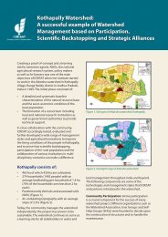
Currently, mechanical erosion control is effected on 12,000 ha <strong>of</strong> cultivated fields. Implementation <strong>of</strong> mechanical<br />
erosion control is carried out under <strong>the</strong> auspices <strong>of</strong> <strong>the</strong> Forum for Integrated Resource Management (FIRM)<br />
participatory approach. <strong>The</strong> technology is <strong>in</strong>cluded <strong>in</strong> <strong>the</strong> <strong>in</strong>tegrated work plans <strong>of</strong> Mathathane village. FIRM<br />
encompasses all important stakeholders and partners, <strong>in</strong>clud<strong>in</strong>g <strong>the</strong> communities <strong>the</strong>mselves, government<br />
departments, village development committee (VDC) and local <strong>in</strong>stitutions.<br />
2.1.3 Up-scal<strong>in</strong>g <strong>the</strong> technology<br />
<strong>The</strong> <strong>in</strong>itial focal po<strong>in</strong>t for up-scal<strong>in</strong>g is Mathathane village. <strong>The</strong>reafter, o<strong>the</strong>r major villages <strong>in</strong> Bobirwa sub district,<br />
that is, Tsetsebjwe and Motlhabaneng, will be brought <strong>in</strong>to <strong>the</strong> fold. Mechanical erosion control measures can be<br />
applied <strong>in</strong> o<strong>the</strong>r countries where <strong>the</strong> climatic and soil regimes are similar to those <strong>of</strong> <strong>the</strong> hardveld. <strong>The</strong> agricultural<br />
extension service <strong>of</strong> <strong>the</strong> M<strong>in</strong>istry <strong>of</strong> Agriculture will be <strong>of</strong> great assistance <strong>in</strong> <strong>the</strong> up-scal<strong>in</strong>g phase.<br />
2.1.4 Contribution to <strong>the</strong> overall DMP project goal and objectives<br />
This technology, if fully implemented, contributes to <strong>the</strong> specific objective <strong>of</strong> develop<strong>in</strong>g and implement<strong>in</strong>g<br />
strategies for conservation, restoration and susta<strong>in</strong>able use <strong>of</strong> dryland biodiversity (Output 2).<br />
2.1.5 Projected potential impact<br />
<strong>The</strong> projected potential impact <strong>of</strong> this technology is to reduce land degradation by putt<strong>in</strong>g more than 48,000 ha <strong>of</strong><br />
potentially erodible arable land under effective mechanical erosion control.<br />
2.2 Local level monitor<strong>in</strong>g (LLM)<br />
Local level monitor<strong>in</strong>g (LLM) is a tool that can be used directly by farmers to collect <strong>in</strong>formation on important<br />
<strong>in</strong>dicators so that <strong>the</strong>y can make timely management decisions and thus better manage <strong>the</strong>ir natural resources. <strong>The</strong><br />
four relevant <strong>in</strong>dicators <strong>of</strong> rangeland conditions are livestock condition, fodder availability/carry<strong>in</strong>g capacity,<br />
ra<strong>in</strong>fall, veld condition and bush density.<br />
272