- Page 1:
Bridgestone Retail Operations, LLC
- Page 5 and 6:
Bismarck Real Estate Partners, Inc.
- Page 7 and 8:
Bismarck Real Estate Partners, Inc.
- Page 9 and 10:
Bridgestone Retail Operations, LLC
- Page 11 and 12:
Bridgestone Retail Operations, LLC
- Page 13:
Bridgestone Retail Operations, LLC
- Page 16 and 17:
Bridgestone Retail Operations, LLC
- Page 18 and 19:
Bridgestone Retail Operations, LLC
- Page 21 and 22:
Bridgestone Retail Operations, LLC
- Page 23 and 24:
Bridgestone Retail Operations, LLC
- Page 28 and 29:
Bridgestone Retail Operations, LLC
- Page 30 and 31:
Bridgestone Retail Operations, LLC
- Page 32 and 33:
Bridgestone Retail Operations, LLC
- Page 34 and 35:
Bridgestone Retail Operations, LLC
- Page 36 and 37:
Bridgestone Retail Operations LLC..
- Page 38 and 39:
Bridgestone Retail Operations LLC..
- Page 40 and 41:
Bridgestone Retail Operations LLC..
- Page 42 and 43:
Bridgestone Retail Operations LLC..
- Page 44 and 45:
Bridgestone Retail Operations LLC..
- Page 46 and 47:
Bridgestone Retail Operations LLC..
- Page 48 and 49:
Bridgestone Retail Operations LLC..
- Page 50 and 51:
Bridgestone Retail Operations LLC..
- Page 52 and 53:
Bridgestone Retail Operations LLC..
- Page 54 and 55:
Bridgestone Retail Operations LLC..
- Page 56 and 57:
Bridgestone Retail Operations LLC..
- Page 58 and 59:
Bridgestone Retail Operations LLC..
- Page 60 and 61:
Bridgestone Retail Operations LLC..
- Page 62 and 63:
Bridgestone Retail Operations LLC..
- Page 64 and 65:
Bridgestone Retail Operations LLC..
- Page 66 and 67:
Bridgestone Retail Operations LLC..
- Page 68 and 69:
Bridgestone Retail Operations LLC..
- Page 70 and 71:
Bridgestone Retail Operations LLC..
- Page 72 and 73:
Bridgestone Retail Operations LLC..
- Page 74 and 75:
Bridgestone Retail Operations LLC..
- Page 76 and 77:
Bridgestone Retail Operations LLC..
- Page 78 and 79:
Bridgestone Retail Operations LLC..
- Page 80 and 81:
Bridgestone Retail Operations LLC..
- Page 82 and 83:
Bridgestone Retail Operations LLC..
- Page 84 and 85:
Bridgestone Retail Operations LLC..
- Page 86 and 87:
Bridgestone Retail Operations LLC..
- Page 88 and 89:
Bridgestone Retail Operations LLC..
- Page 90 and 91:
Bridgestone Retail Operations LLC..
- Page 92 and 93:
Bridgestone Retail Operations LLC..
- Page 94 and 95:
Bridgestone Retail Operations LLC..
- Page 96 and 97:
Bridgestone Retail Operations LLC..
- Page 98 and 99:
Bridgestone Retail Operations LLC..
- Page 100:
Bridgestone Retail Operations LLC..
- Page 103 and 104:
Bridgestone Retail Operations, LLC
- Page 106 and 107:
Bridgestone Retail Operations, LLC
- Page 108 and 109:
Bridgestone Retail Operations, LLC
- Page 110 and 111:
Bridgestone Retail Operations, LLC
- Page 112 and 113:
Bridgestone Retail Operations, LLC
- Page 114 and 115:
Bridgestone Retail Operations, LLC
- Page 116 and 117:
Bridgestone Retail Operations, LLC
- Page 118 and 119:
Bridgestone Retail Operations, LLC
- Page 120 and 121:
Bridgestone Retail Operations, LLC
- Page 122 and 123:
Bridgestone Retail Operations, LLC
- Page 124 and 125:
Bridgestone Retail Operations, LLC
- Page 126 and 127:
Bridgestone Retail Operations, LLC
- Page 128:
Bridgestone Retail Operations, LLC
- Page 131 and 132:
Bridgestone Retail Operations, LLC
- Page 133 and 134:
Bridgestone Retail Operations, LLC
- Page 135 and 136:
Bridgestone Retail Operations, LLC
- Page 138 and 139:
Bridgestone Retail Operations, LLC
- Page 140 and 141:
Bridgestone Retail Operations, LLC
- Page 142 and 143:
Bridgestone Retail Operations, LLC
- Page 144 and 145:
Bridgestone Retail Operations, LLC
- Page 146:
Bridgestone Retail Operations, LLC
- Page 149 and 150:
Bridgestone Retail Operations, LLC
- Page 152 and 153:
Bridgestone Retail Operations, LLC
- Page 154 and 155:
Bridgestone Retail Operations, LLC
- Page 156 and 157:
Bridgestone Retail Operations, LLC
- Page 158 and 159:
Bridgestone Retail Operations, LLC
- Page 160 and 161:
Bridgestone Retail Operations, LLC
- Page 162:
Bridgestone Retail Operations, LLC
- Page 165 and 166:
Bridgestone Retail Operations, LLC
- Page 168:
Bridgestone Retail Operations, LLC
- Page 172 and 173:
Bridgestone Retail Operations, LLC
- Page 174 and 175:
Bridgestone Retail Operations, LLC
- Page 176:
Bridgestone Retail Operations, LLC
- Page 180 and 181:
Bridgestone Retail Operations, LLC
- Page 182 and 183:
Bridgestone Retail Operations, LLC
- Page 184 and 185:
Bridgestone Retail Operations, LLC
- Page 186 and 187:
Bridgestone Retail Operations, LLC
- Page 188 and 189:
Bridgestone Retail Operations, LLC
- Page 190:
Bridgestone Retail Operations, LLC
- Page 193 and 194:
Bridgestone Retail Operations, LLC
- Page 195 and 196:
Bridgestone Retail Operations, LLC
- Page 197 and 198:
Bridgestone Retail Operations, LLC
- Page 199 and 200:
Bridgestone Retail Operations, LLC
- Page 202 and 203:
Bridgestone Retail Operations, LLC
- Page 204 and 205:
Bridgestone Retail Operations, LLC
- Page 206 and 207:
Bridgestone Retail Operations, LLC
- Page 208 and 209:
Bridgestone Retail Operations, LLC
- Page 210 and 211:
Bridgestone Retail Operations, LLC
- Page 212:
Bridgestone Retail Operations, LLC
- Page 215 and 216:
Bridgestone Retail Operations, LLC
- Page 217 and 218:
Bridgestone Retail Operations, LLC
- Page 219 and 220:
Bridgestone Retail Operations, LLC
- Page 221 and 222:
Bridgestone Retail Operations, LLC
- Page 223 and 224:
Bridgestone Retail Operations, LLC
- Page 225 and 226:
Bridgestone Retail Operations, LLC
- Page 228 and 229:
Bridgestone Retail Operations, LLC
- Page 230 and 231:
Bridgestone Retail Operations, LLC
- Page 232 and 233:
Bridgestone Retail Operations, LLC
- Page 234 and 235:
Bridgestone Retail Operations, LLC
- Page 236 and 237:
Bridgestone Retail Operations, LLC
- Page 238:
Bridgestone Retail Operations, LLC
- Page 241 and 242:
Bridgestone Retail Operations, LLC
- Page 244 and 245:
Bridgestone Retail Operations, LLC
- Page 246 and 247:
Bridgestone Retail Operations, LLC
- Page 248:
Bridgestone Retail Operations, LLC
- Page 251 and 252:
Bridgestone Retail Operations, LLC
- Page 253 and 254:
Bridgestone Retail Operations, LLC
- Page 255 and 256:
Bridgestone Retail Operations, LLC
- Page 257 and 258:
Bridgestone Retail Operations, LLC
- Page 259 and 260:
Bridgestone Retail Operations, LLC
- Page 262 and 263:
Bridgestone Retail Operations, LLC
- Page 264:
Bridgestone Retail Operations, LLC
- Page 267 and 268:
Bridgestone Retail Operations LLC P
- Page 270 and 271:
Bridgestone Retail Operations, LLC
- Page 272 and 273:
Bridgestone Retail Operations, LLC
- Page 274:
Bridgestone Retail Operations, LLC
- Page 277 and 278:
Bridgestone Retail Operations, LLC
- Page 280 and 281:
Bridgestone Retail Operations, LLC
- Page 282:
Bridgestone Retail Operations, LLC
- Page 285 and 286:
Bridgestone Retail Operations, LLC
- Page 287 and 288:
Bridgestone Retail Operations, LLC
- Page 289 and 290:
Bridgestone Retail Operations, LLC
- Page 292:
Bridgestone Retail Operations, LLC
- Page 296 and 297:
Bridgestone Retail Operations, LLC
- Page 298:
Bridgestone Retail Operations, LLC
- Page 301 and 302:
Bridgestone Retail Operations, LLC
- Page 303 and 304:
Bridgestone Retail Operations, LLC
- Page 305 and 306:
Bridgestone Retail Operations, LLC
- Page 308 and 309:
Bridgestone Retail Operations, LLC
- Page 310 and 311:
Bridgestone Retail Operations, LLC
- Page 312:
Bridgestone Retail Operations, LLC
- Page 315 and 316:
Bridgestone Retail Operations, LLC
- Page 317 and 318:
Bridgestone Retail Operations, LLC
- Page 320 and 321:
Bridgestone Retail Operations, LLC
- Page 322:
Bridgestone Retail Operations, LLC
- Page 325 and 326:
Bridgestone Retail Operations, LLC
- Page 328 and 329:
Bridgestone Retail Operations, LLC
- Page 330:
Bridgestone Retail Operations, LLC
- Page 333 and 334:
Bridgestone Retail Operations, LLC
- Page 336 and 337:
Bridgestone Retail Operations, LLC
- Page 338 and 339:
Bridgestone Retail Operations, LLC
- Page 340:
Bridgestone Retail Operations, LLC
- Page 343 and 344:
Bridgestone Retail Operations, LLC
- Page 345 and 346:
Bridgestone Retail Operations, LLC
- Page 347 and 348:
Bridgestone Retail Operations, LLC
- Page 349 and 350:
Bridgestone Retail Operations, LLC
- Page 351 and 352:
Bridgestone Retail Operations, LLC
- Page 353 and 354:
Bridgestone Retail Operations, LLC
- Page 356 and 357:
Bridgestone Retail Operations, LLC
- Page 358 and 359:
Bridgestone Retail Operations, LLC
- Page 360:
Bridgestone Retail Operations, LLC
- Page 363 and 364:
Bridgestone Retail Operations, LLC
- Page 366 and 367:
Bridgestone Retail Operations, LLC
- Page 368 and 369:
Bridgestone Retail Operations, LLC
- Page 370 and 371:
Bridgestone Retail Operations, LLC
- Page 372 and 373:
Bridgestone Retail Operations, LLC
- Page 374 and 375:
Bridgestone Retail Operations, LLC
- Page 376 and 377:
Bridgestone Retail Operations, LLC
- Page 378 and 379:
Bridgestone Retail Operations, LLC
- Page 380 and 381:
Bridgestone Retail Operations, LLC
- Page 382 and 383:
Bridgestone Retail Operations, LLC
- Page 384 and 385:
Bridgestone Retail Operations, LLC
- Page 386:
Bridgestone Retail Operations, LLC
- Page 389 and 390:
Bridgestone Retail Operations, LLC
- Page 391 and 392:
Bridgestone Retail Operations, LLC
- Page 393 and 394:
Bridgestone Retail Operations, LLC
- Page 395 and 396:
Bridgestone Retail Operations, LLC
- Page 397 and 398:
Bridgestone Retail Operations, LLC
- Page 399 and 400:
Bridgestone Retail Operations, LLC
- Page 402 and 403:
Bridgestone Retail Operations, LLC
- Page 404 and 405:
Bridgestone Retail Operations LLC P
- Page 406 and 407:
Bridgestone Retail Operations LLC P
- Page 408 and 409:
Bridgestone Retail Operations LLC P
- Page 410 and 411:
Bridgestone Retail Operations, LLC
- Page 412 and 413:
Bridgestone Retail Operations, LLC
- Page 414 and 415:
Bridgestone Retail Operations, LLC
- Page 416:
Bridgestone Retail Operations, LLC
- Page 419 and 420:
Bridgestone Retail Operations, LLC
- Page 422 and 423:
Bridgestone Retail Operations, LLC
- Page 424 and 425:
Bridgestone Retail Operations, LLC
- Page 426 and 427:
Bridgestone Retail Operations, LLC
- Page 428:
Bridgestone Retail Operations, LLC
- Page 431 and 432:
Bridgestone Retail Operations, LLC
- Page 433 and 434:
Bridgestone Retail Operations, LLC
- Page 436 and 437:
Bridgestone Retail Operations, LLC
- Page 438 and 439:
Bridgestone Retail Operations, LLC
- Page 440 and 441:
Bridgestone Retail Operations, LLC
- Page 442 and 443:
Bridgestone Retail Operations, LLC
- Page 444 and 445:
Bridgestone Retail Operations, LLC
- Page 446 and 447:
Bridgestone Retail Operations, LLC
- Page 448 and 449:
Bridgestone Retail Operations, LLC
- Page 450 and 451:
Bridgestone Retail Operations, LLC
- Page 452 and 453:
Bridgestone Retail Operations, LLC
- Page 454 and 455:
Bridgestone Retail Operations, LLC
- Page 456 and 457:
Bridgestone Retail Operations, LLC
- Page 458 and 459:
Bridgestone Retail Operations, LLC
- Page 460:
Bridgestone Retail Operations, LLC
- Page 463 and 464:
Bridgestone Retail Operations, LLC
- Page 465 and 466:
Bridgestone Retail Operations, LLC
- Page 467 and 468:
Bridgestone Retail Operations, LLC
- Page 469 and 470:
Bridgestone Retail Operations, LLC
- Page 471 and 472:
Bridgestone Retail Operations, LLC
- Page 473 and 474:
Bridgestone Retail Operations, LLC
- Page 475 and 476:
Bridgestone Retail Operations, LLC
- Page 477 and 478:
Bridgestone Retail Operations, LLC
- Page 479 and 480:
Bridgestone Retail Operations, LLC
- Page 481 and 482:
Bridgestone Retail Operations, LLC
- Page 483 and 484:
Bridgestone Retail Operations, LLC
- Page 485 and 486:
Bridgestone Retail Operations, LLC
- Page 487 and 488:
Bridgestone Retail Operations, LLC
- Page 489 and 490:
Bridgestone Retail Operations, LLC
- Page 491 and 492:
Bridgestone Retail Operations, LLC
- Page 493 and 494:
Bridgestone Retail Operations, LLC
- Page 495 and 496:
Bridgestone Retail Operations, LLC
- Page 498 and 499:
Bridgestone Retail Operations, LLC
- Page 500 and 501:
Bridgestone Retail Operations, LLC
- Page 502:
Bridgestone Retail Operations, LLC
- Page 506 and 507:
Bridgestone Retail Operations, LLC
- Page 508 and 509:
Bridgestone Retail Operations, LLC
- Page 510:
Bridgestone Retail Operations, LLC
- Page 513 and 514:
Bridgestone Retail Operations, LLC
- Page 516 and 517:
Bridgestone Retail Operations, LLC
- Page 518 and 519:
Bridgestone Retail Operations, LLC
- Page 520 and 521:
Bridgestone Retail Operations, LLC
- Page 522 and 523:
Bridgestone Retail Operations, LLC
- Page 524:
Bridgestone Retail Operations, LLC
- Page 527 and 528:
Bridgestone Retail Operations, LLC
- Page 529 and 530:
Bridgestone Retail Operations, LLC
- Page 531 and 532:
Bridgestone Retail Operations, LLC
- Page 533 and 534:
Bridgestone Retail Operations, LLC
- Page 536:
Bridgestone Retail Operations, LLC
- Page 540 and 541:
Bridgestone Retail Operations, LLC
- Page 542:
Bridgestone Retail Operations, LLC
- Page 546: Bridgestone Retail Operations, LLC
- Page 549 and 550: Bridgestone Retail Operations, LLC
- Page 552 and 553: Bridgestone Retail Operations, LLC
- Page 554: Bridgestone Retail Operations, LLC
- Page 558: Bridgestone Retail Operations, LLC
- Page 562 and 563: Bridgestone Retail Operations, LLC
- Page 564 and 565: Bridgestone Retail Operations, LLC
- Page 566: Bridgestone Retail Operations, LLC
- Page 570 and 571: Bridgestone Retail Operations, LLC
- Page 572 and 573: Bridgestone Retail Operations, LLC
- Page 574 and 575: Bridgestone Retail Operations, LLC
- Page 576 and 577: Bridgestone Retail Operations, LLC
- Page 578 and 579: Bridgestone Retail Operations, LLC
- Page 580 and 581: Bridgestone Retail Operations, LLC
- Page 582: Bridgestone Retail Operations, LLC
- Page 585 and 586: Bridgestone Retail Operations, LLC
- Page 587 and 588: Bridgestone Retail Operations, LLC
- Page 589: Bridgestone Retail Operations, LLC
- Page 592 and 593: REPORT OF GEOTECHNICAL ENGINEERING
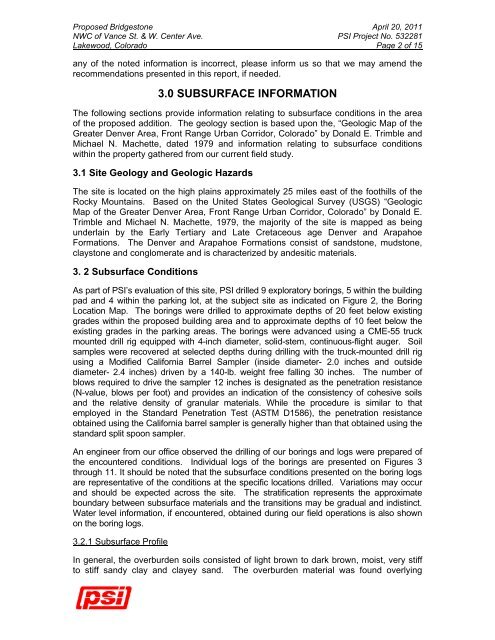
- Page 596 and 597: Proposed Bridgestone April 20, 2011
- Page 598 and 599: Proposed Bridgestone April 20, 2011
- Page 600 and 601: Proposed Bridgestone April 20, 2011
- Page 602 and 603: Proposed Bridgestone April 20, 2011
- Page 604 and 605: Proposed Bridgestone April 20, 2011
- Page 606 and 607: Proposed Bridgestone April 20, 2011
- Page 608 and 609: Proposed Bridgestone April 20, 2011
- Page 611 and 612: FIGURE: 3 DATE STARTED: 4/5/11 DRIL
- Page 613 and 614: FIGURE: 5 DATE STARTED: 4/5/11 DRIL
- Page 615 and 616: FIGURE: 7 DATE STARTED: 4/5/11 DRIL
- Page 617 and 618: FIGURE: 9 DATE STARTED: 4/5/11 DRIL
- Page 619 and 620: FIGURE: 11 DATE STARTED: 4/5/11 DRI
- Page 621 and 622: APPENDIX A Laboratory Test Results
- Page 623 and 624: 12 SWELL-CONSOLIDATION TEST 10 8 6
- Page 625 and 626: 12 SWELL-CONSOLIDATION TEST 10 8 6
- Page 627 and 628: 12 SWELL-CONSOLIDATION TEST 10 8 6
- Page 629 and 630: 12 SWELL-CONSOLIDATION TEST 10 8 6
- Page 631 and 632: 10 SWELL-CONSOLIDATION TEST 8 6 4 2
- Page 633 and 634: 12 SWELL-CONSOLIDATION TEST 10 8 6
- Page 635 and 636: 12 SWELL-CONSOLIDATION TEST 10 8 6
- Page 637 and 638: 12 SWELL-CONSOLIDATION TEST 10 8 6
- Page 639 and 640: June 21, 2012 Bridgestone Retail Op
- Page 641 and 642: Bridgestone/Firestone - Lakewood, C
- Page 643 and 644: Bridgestone/Firestone - Lakewood, C