- Page 3 and 4:
Universidad Autónoma de Ciudad Ju
- Page 5 and 6:
ISBN electrónico: 978-607-520-150-
- Page 7 and 8:
Predicción y modelación del creci
- Page 9 and 10:
Capítulo VII La Geoinformática co
- Page 11 and 12:
ización de procesos de degradació
- Page 13 and 14:
nicas como la superposición manual
- Page 15 and 16:
inundación, que genera como consec
- Page 17 and 18:
una base de datos, hasta su procesa
- Page 19 and 20:
1. Preparación y obtención de la
- Page 21 and 22:
Figura 2. Mapa de manzanas y lotes
- Page 23 and 24:
Tipo Precio 1 Precio 2 Precio 3 Bie
- Page 25 and 26:
Figura 3. Mapa de zonas potenciales
- Page 27 and 28:
colonia “Francisco Villa”, tal
- Page 29 and 30:
Figura 6. Potencial de afectación.
- Page 31 and 32:
Tabla 3. Tabla de estimación de p
- Page 33 and 34:
Salas Salinas, M.A., Jiménez Espin
- Page 35 and 36:
Pemex en Reynosa, Tamaulipas. En es
- Page 37 and 38:
trico, indicando las construcciones
- Page 39 and 40:
Figura 1. Mapa de área de estudio.
- Page 41 and 42:
• Ubicación como calles y coloni
- Page 43 and 44:
Proceso de materiales y métodos B
- Page 45 and 46:
Información de trabajo en campo Se
- Page 47 and 48:
Instalaciones estables e inestables
- Page 49 and 50:
Al igual que el ejemplo anterior, e
- Page 51 and 52:
Leyenda Gaseras Condición • Esta
- Page 53 and 54:
Leyenda Gaseras Condición • Esta
- Page 55 and 56:
cerca de una gasera, y pueda existi
- Page 57 and 58:
NOM-124-ECOL-1999 (1999). Especific
- Page 59 and 60:
tránsito (AT). Esto equivale a 1.2
- Page 61 and 62:
gubernamentales a tener mayor inter
- Page 63 and 64:
total de países de la región, dur
- Page 65 and 66:
vedad y pasar del conocimiento y de
- Page 67 and 68:
se podía apreciar cuales eran las
- Page 69 and 70:
Average Nearest Neighbor Summary Re
- Page 71 and 72:
La categoría de Moderado se presen
- Page 73 and 74:
La intersección del boulevard Fern
- Page 75 and 76:
entroncando con carretera Cuauhtém
- Page 77 and 78:
Distribución de accidentes del mi
- Page 79 and 80:
Leyenda Mínimo Bajo 1-2 Moderado 2
- Page 81 and 82:
de fin de semana que probablemente
- Page 83 and 84:
Leyenda Mínimo Bajo 1-2 Moderado 2
- Page 85 and 86:
Esto se debe a diferentes factores
- Page 87 and 88:
2011, http://www.jornada.unam.mx/20
- Page 89 and 90:
ciudades. Dicha planificación esta
- Page 92 and 93:
Identificación de patrones de crec
- Page 94 and 95:
2010), esto como consecuencia de la
- Page 96 and 97:
debido a la formación de manchas m
- Page 98 and 99:
Las herramientas proporcionadas por
- Page 100 and 101:
Se realizó fotointerpretación, qu
- Page 102 and 103:
Nombre clase Descripción Imagen Us
- Page 104 and 105:
espacial del raster (ESRI, 2012). L
- Page 106 and 107:
software Fragstats en su versión 4
- Page 108 and 109:
Leyenda 2010 Tipo Urbano Comercial
- Page 110 and 111:
El área mixta aumentó en el área
- Page 112 and 113:
En contraste, se observa que en otr
- Page 114:
Pardo Montaño, A. M. (Agosto de 20
- Page 117 and 118:
de población realizadas para el a
- Page 119 and 120:
de éste fruto requiere de una impo
- Page 121 and 122:
Figura 1. Área de estudio. Cartogr
- Page 123 and 124:
generar superficies suavemente vari
- Page 125 and 126: en el área de estudio es el de mic
- Page 127 and 128: Figura 4. Comportamiento de los req
- Page 129 and 130: Comparación de los consumos de agu
- Page 131 and 132: Superficie suavizada (Spline) con l
- Page 133 and 134: Con base a lo expuesto anteriorment
- Page 135 and 136: cola representa la principal fuente
- Page 137 and 138: del Consejo Nacional de Ciencia y T
- Page 139 and 140: Anexo 2 Simbología Interpolación
- Page 141 and 142: Anexo 4 Simbología Spline (metros
- Page 143 and 144: topografía y las construcciones de
- Page 145 and 146: eferencia a los datos de entrada qu
- Page 147 and 148: Datos de entrada Valores Área urba
- Page 149 and 150: Leyenda U Urbano A Agrícola NU No
- Page 151 and 152: e) Red de transporte (transportatio
- Page 153 and 154: g) Formato de entrada Las imágenes
- Page 155 and 156: a) Calibración gruesa En esta fase
- Page 157 and 158: lizó una digitalización de las á
- Page 159 and 160: la probabilidad de 0 a 20% y de 50
- Page 161 and 162: ano, ya que con estos se obtienen l
- Page 163 and 164: Márquez Lobato, B. Y. (2008). Aná
- Page 165 and 166: crecimiento poblacional han disminu
- Page 167 and 168: la nueva forma de tenencia de la ti
- Page 169 and 170: Objetivos específicos • Determin
- Page 171 and 172: Cuadro 1. Tipología utilizada para
- Page 173 and 174: Cabe señalar que todos los factore
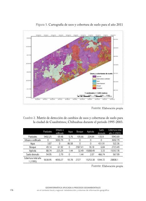
- Page 175: Cabe señalar que uno de los cambio
- Page 179 and 180: Modelo de predicción de uso y cobe
- Page 181 and 182: Figura 7. Resultado del modelo de p
- Page 183 and 184: aguas subterráneas comienzan a ser
- Page 185 and 186: principalmente si la pérdida de pr
- Page 187 and 188: Barreira Gónzalez, P., Aguilera Be
- Page 189 and 190: Rionda Ramírez, J. I. (2007). Desa
- Page 191 and 192: Anexo 1 Secuencia metodológica Def
- Page 193 and 194: Anexo 4. Mapa de aptitud para uso a
- Page 195 and 196: Anexo 8. Mapa de aptitud para cober
- Page 197 and 198: ficial, y se reconocen como una cue
- Page 199 and 200: Asselman, N.E.M., Middelkoop, H. y
- Page 201 and 202: la desertificación, cada año deja
- Page 203 and 204: cerra, 1998). Las dificultades que
- Page 205 and 206: Figura 2. Mapa de cobertura y usos
- Page 207 and 208: propuestos por Téllez, Hutchinson,
- Page 209 and 210: El factor de erodibilidad del suelo
- Page 211 and 212: Tabla 6. Valores para el factor C a
- Page 213 and 214: Figura 5. Mapa de disección vertic
- Page 215 and 216: tras que los suelos de textura grue
- Page 217 and 218: Figura 9. Factor LS. Aplicación de
- Page 219 and 220: 1200 1000 Área en Km 2 800 600 400
- Page 221 and 222: diseccionadas. Por otra parte, las
- Page 223 and 224: Wischmeier, W., y Smith, D. (1978).
- Page 225 and 226: y este porcentaje podría increment
- Page 228 and 229:
Relaciones espaciales entre los cam
- Page 230 and 231:
micas de los productores en cada un
- Page 232 and 233:
Lamentablemente, no existen muchas
- Page 234 and 235:
Figura 3. Tenencia de la tierra en
- Page 236 and 237:
En el análisis, se utilizaron los
- Page 238 and 239:
La zona de alto abatimiento (56,700
- Page 240 and 241:
Tabla 6. Prueba Chi cuadrada para c
- Page 242 and 243:
En el área de recarga también se
- Page 244 and 245:
2007). Esta diferencia de precios v
- Page 246 and 247:
Bankkoff, G. (2004). The Historical
- Page 248 and 249:
Cartografía de referencia Colonia
- Page 250 and 251:
Análisis y aplicación de un model
- Page 252 and 253:
áreas de recarga y por otra, a que
- Page 254 and 255:
Figura 1. Zona de Estudio. La recar
- Page 256 and 257:
manejo del recurso del agua, se bus
- Page 258 and 259:
El último modelo identificado es u
- Page 260 and 261:
Cuadro 6. Ponderación de la posibi
- Page 262 and 263:
d) Aplicación del modelo propuesto
- Page 264 and 265:
F, en función del área que repres
- Page 266 and 267:
Se seleccionó un modelo aplicado p
- Page 268 and 269:
de http://siteresources.worldbank.o
- Page 270 and 271:
CAPÍTULO V Geoinformática aplicad
- Page 272 and 273:
En el noroeste de México son escas
- Page 274 and 275:
Delbart N, Picard G, Le Toan T, Ker
- Page 276:
means of AVHRR images and climate i
- Page 279 and 280:
ellos evita los procesos de erosió
- Page 281 and 282:
METODOLOGÍA Área de estudio El á
- Page 283 and 284:
sario hacer una reclasificación en
- Page 285 and 286:
Figura 3. Valores de NDVI pre- ince
- Page 287 and 288:
Tabla 2. Área afectada por cada ra
- Page 289 and 290:
Tabla 4. Área afectada por cada ra
- Page 291 and 292:
En cambio las categorías de Severi
- Page 293 and 294:
Montorio, R., Perez-cabello, F., Ga
- Page 295 and 296:
más bajas se registran entre los m
- Page 297 and 298:
ÁREA DE ESTUDIO El área de estudi
- Page 299 and 300:
píxel. Finalmente el modelo de cla
- Page 301 and 302:
de reflectividad, para el mes de ma
- Page 303 and 304:
indicando una posible tendencia neg
- Page 305 and 306:
Análisis por tenencia de la tierra
- Page 307 and 308:
de la conservación de áreas fores
- Page 309 and 310:
GEOINFORMÁTICA APLICADA A PROCESOS
- Page 311 and 312:
Cabe hacer una distinción entre lo
- Page 313 and 314:
MATERIALES Y MÉTODOS Descripción
- Page 315 and 316:
Tabla 1. Datos de las imágenes Lan
- Page 317 and 318:
Las clasificaciones basadas en resp
- Page 319 and 320:
entre categorías, en conclusión r
- Page 321 and 322:
Tabla 5. Propuesta de clasificació
- Page 323 and 324:
Figura 2. Cobertura Vegetal año 20
- Page 325 and 326:
es decir que tuvo una pérdida cons
- Page 327 and 328:
Figura 6. Propiedad privada 2011. F
- Page 329 and 330:
Figura 8. Propiedad ejidal 2011. Fu
- Page 331 and 332:
Figura 9. Tabulación Cruzada Ejido
- Page 333 and 334:
Tabla 11. Tasa de deforestación an
- Page 335 and 336:
Cerda, J. y Villarroel, L. (2008).
- Page 338 and 339:
CAPÍTULO VI Geoinformática aplica
- Page 340:
Fierro Macias Carlos Daniel, Torres
- Page 343 and 344:
Ara militaris es la especie que pre
- Page 345 and 346:
prohíbe su comercialización como
- Page 347 and 348:
anías de clima suave, mesas y mese
- Page 349 and 350:
meses de mayo a agosto y la más ba
- Page 351 and 352:
Con base a la norma oficial mexican
- Page 353 and 354:
de máxima entropía (Maxent) para
- Page 355 and 356:
gidos al azar del área de estudio
- Page 357 and 358:
Figura 3. Mapa consenso obtenido po
- Page 359 and 360:
Figura 7. Curva operada por el rece
- Page 361 and 362:
solución por medio de una ruta dis
- Page 363 and 364:
Figura 10. Análisis “Jackknife
- Page 365 and 366:
y la escala geográfica, dependiend
- Page 367 and 368:
Herbert J. 2006. Distribution, habi
- Page 369 and 370:
GEOINFORMÁTICA APLICADA A PROCESOS
- Page 371 and 372:
Por muchos años se ignoraron los t
- Page 373 and 374:
Figura 1. Distribución histórica
- Page 375 and 376:
se da el nicho ecológico fundament
- Page 377 and 378:
do con 15.4% del territorio, el muy
- Page 379 and 380:
Cuadro 1. Envolventes ambientales.
- Page 381 and 382:
leccionados (42%). El mapa de ausen
- Page 383 and 384:
La distribución histórica del ven
- Page 385 and 386:
Figura 7. Curvas de respuesta de la
- Page 387 and 388:
Chillo, V., y Ojeda, R. 2012. “Ma
- Page 390 and 391:
Modelación del Potencial Actual de
- Page 392 and 393:
los ecosistemas, los hábitats, la
- Page 394 and 395:
Antecedentes del modelo de MaxEnt (
- Page 396 and 397:
te 109°07’ de longitud oeste Chi
- Page 398 and 399:
Tabla 1. Variables bioclimáticas d
- Page 400 and 401:
default; continuando se seleccionó
- Page 402 and 403:
atributo de 3 (áreas con las condi
- Page 404 and 405:
entre la proporción de acuerdo obs
- Page 406 and 407:
• mex_slo: Esta variable contiene
- Page 408 and 409:
a .908 son áreas en las que las co
- Page 410 and 411:
Figura 11. Mapas de condiciones, es
- Page 412 and 413:
las especies sobrevivan, de .675 a
- Page 414 and 415:
Mapa de Idoneidad Potencial Actual
- Page 416 and 417:
Figura 19. Mapa de idoneidad del po
- Page 418 and 419:
Tabla de concordancia de idoneidad
- Page 420 and 421:
Figura 21. Mapa de pérdida de idon
- Page 422 and 423:
les de 1996 y 2000, que consideran
- Page 424 and 425:
La aplicación del método de máxi
- Page 426 and 427:
Mateo R., Felicísimo A. 2011. “M
- Page 428 and 429:
CAPÍTULO VII La Geoinformática co
- Page 430 and 431:
El trabajo de Claudia Legarreta es
- Page 432 and 433:
Correlación entre indicadores soci
- Page 434 and 435:
Finalmente es importante afirmar qu
- Page 436 and 437:
1. Comprender cómo se correlaciona
- Page 438 and 439:
Adicionalmente, el trabajo presente
- Page 440 and 441:
secuencia, una buena escuela es una
- Page 442 and 443:
10. Elemental en Ciencias 11. Bueno
- Page 444 and 445:
• Evaluación Nacional del Logro
- Page 446 and 447:
Figura 1. Ciudad Cuauhtémoc Chihua
- Page 448 and 449:
Una vez que se terminó esta parte
- Page 450 and 451:
la fiabilidad es media. En cambio s
- Page 452 and 453:
Escuela Hogar y familia Comunidad C
- Page 454 and 455:
mayor demanda y disposición de és
- Page 456 and 457:
Los indicadores de rendimiento son
- Page 458 and 459:
La matrícula es atendida por cerca
- Page 460 and 461:
más adelante, las escuelas que se
- Page 462 and 463:
que los resultados de la prueba se
- Page 464 and 465:
Figura 7. Grado de Marginación en
- Page 466 and 467:
instituciones educativas cuyo anál
- Page 468 and 469:
Cuadro 4. Las cinco escuelas con lo
- Page 470 and 471:
Escuela “Ricardo Flores Magón”
- Page 472 and 473:
es más factible esperar que los ni
- Page 474 and 475:
sin embargo también es importante
- Page 476 and 477:
conclusiones, fue posible ir encont
- Page 478 and 479:
Martínez Ortega, R. M., Tuya Pend